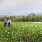
Schluckebier Sand Prairie

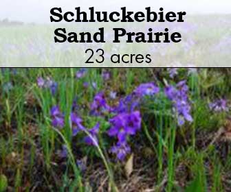
Prairie violet by Joshua Mayer
Schluckebier Sand Prairie
Schluckebier Sand Prairie, one of the last surviving remnants of the 14,000 acre Sauk Prairie Sauk , a vast grassland that covered the area prior to European settlement. The small dry to dry-mesic prairie is situated on part of an old Wisconsin River terrace. The prairie supports a good diversity of native plants and insects. Including plants such as little bluestem, June grass, Virginia dwarf dandelion, short green milkweed, bird’s-foot violet, pasque flower, prairie smoke, flowering spurge, spiderwort, and rough blazing-star.
Except for a few small patches on slopes and along the edges, it is believed that the entire site had been plowed as early as the 1850’s. An area to the south was also grazed until 1969. Because of its sandy soil and rapid depletion of nutrients, the site was abandoned for cultivation purposes and native species that had disappeared were able to recolonize the prairie. Also present, perhaps due in part to human disturbance, are sand blows that provide microhabitats for specialists like false heather, a pioneer plant that helps stabilize the sand blows. Today, with a management regime of prescribed fire, brushing, and invasives control the condition of the prairie is improving. Schluckebier (SCHLUCK-e-beer) is a German name meaning “drink a beer”. The site is owned by The Prairie Enthusiasts and was designated a State Natural Area in 2006.
ACCESS & DIRECTIONS
Take US Highway 12 west of Sauk City until you get to the light at County PF. Turn left (west) onto Co. PF and travel 1.5 miles, at which point there is a dirt lane immediately beyond a row of trees on the left. Turn left (south) into the lane and look for the small mowed parking area about 100 down the lane.
Google Map
Description & Significance
The prairie supports a good diversity of native plants and insects.
Notable Species:
- prairie bush-clover (Lespedeza leptostachya)
- little bluestem (Schizachyrium scoparium)
- June grass (Koeleria macrantha)
- Virginia dwarf dandelion (Krigia virginica)
- short green milkweed (Asclepias viridiflora)
- bird’s-foot violet (Viola pedata)
- pasqueflower (Anemone patens)
- prairie smoke (Geum triflorum)
- flowering spurge (Euphorbia corollata)
- spiderwort
- rough blazing star (Liatris aspera)
Sand prairie is a dry native grassland community dominated by grasses such as little bluestem, J junegrass, panic grasses, and poverty-oat grass. Common herbaceous associates are sand cress, field sage-wort, western ragweed, several sedges (e.g., Carex muhlenbergii, Cyperus filiculmis, and Cyperus schweinitzii), flowering spurge, frostweed, round-headed bush-clover, western sunflower, false-heather, long-bearded hawkweed, stiff goldenrod, horsebalm, and spiderwort. Drought-adapted fungi, lichens, and mosses are significant components of sand prairie communities.

Management

Except for a few small patches on slopes and along the edges, it is believed that the entire site had been plowed as early as the 1850s. An area to the south was also grazed until 1969. Because of its sandy soil and rapid depletion of nutrients, the site was abandoned for cultivation purposes and native species that had disappeared were able to recolonize the prairie. Also present, perhaps due in part to human disturbance, are sand blows that provide microhabitats for specialists like false heather, a pioneer plant that helps stabilize the sand blows. Today, with a management regime of prescribed fire, brushing, and invasives control the condition of the prairie is improving.