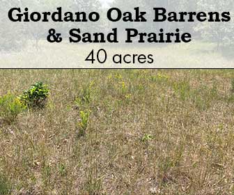
Giordano Oak Barrens & Sand Prairie
Giordano Oak Barrens & Sand Prairie
More information coming soon!
SITE STEWARDS
This is site is not currently open to the public.
More information coming soon!
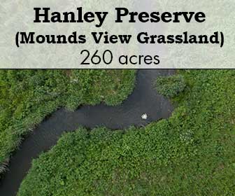
A birds-eye view of the rolling landscape of Hanley Farm. Photo by Eric Preston.
A birds-eye view of the rolling landscape of Hanley Farm. Photo by Eric Preston.
More information coming soon!
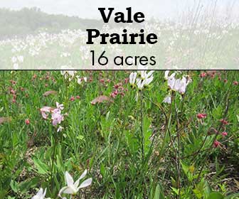

Photo credit: Jerry Newman
The Vale Prairie has over 70 species of native prairie plants, some of which are endangered, threatened and of special concern here in Wisconsin. This remnant is also home to the federally threatened prairie bush clover, a very rare plant found only in the upper Midwest!
The state endangered pink milkwort is also found here. This remnant is the only protected site in the state where this plant has been found as of 1999. Other outstanding qualities of the site are its prairie smoke and shooting star displays.
Hiking here is considered moderately challenging. There are no trails, parts are rocky, and there are badger holes to be wary of.
From Albany, go west on Mineral Point Road to Purinton Road. Continue west to Schneeberger Road, turn right (north) and go about 4/10 of a mile, and park along the road. Walk in to the west of Schneeberger, on a rutted dirt track along a fence line, a quarter-mile on our narrow easement between crop fields.


The remnant was first located in the mid 1970’s. Back then there was no such thing as The Prairie Enthusiasts. There was just a small bunch of guys who loved prairies and liked to burn them, then drink beer and talk about preserving remnants. The Vale Prairie was managed for about five years, then left to its own until 1992, when the Southwest Chapter purchased the 4.5 acre remnant and 11.5 acre buffer for a total of 16 acres. That was truly a fine purchase. The site was named the Vale Prairie after the owners, Harold and Crescent Vale, who were in favor of its protection and restoration.
Photo by Jerry Newman

In the winter of 1993, TPE volunteers and Wisconsin Conservation Corps crews cut and stump treated all woody vegetation on the site. After eight years of work, the area is recovering nicely. Part of the restoration plan involved replanting an area of 1.5 acres in the southwest corner of the property because smooth brome had completely taken over. Our plan was to spray it with Roundup, collect seed, and replant. The spraying was done, and several months later, to our complete amazement, most of the regrowth was of prairie plants, apparently released to grow when the brome was killed! It was decided that the buffer areas would serve as a sort of genetic refuge for disappearing species from within Green County. Two species that have been nearly extirpated in Green County are Wild Quinine and Pale Purple Coneflower, so seed was collected from one coneflower site and three quinine sites and sown there. We now have a healthy and growing population of these plants.
Photo by Jerry Newman

In addition, part of the restoration plan involved expanding the remnant size, but only by using seed from the remnant. To date, a strip 30 feet by 400 feet has been restored on the south edge, and another area on the west end, measuring 45 feet by 100 feet, also has been restored. Areas that were heavily shaded by dense trees and brush have been mowed annually with a sickle bar mower. These areas are difficult to work with due to the fact that birds used the trees as perches for years, and as we all know, where there are birds, there are bird droppings, usually laced with seeds of everything except prairie plants! Once the shady trees are gone, these seeds grow like crazy. Presently the remnant is surrounded by old hayfields dominated by orchard grass. It does serve as a grassland habitat for some bird species, but our hopes are to plant these areas to prairie as well.
Photo by Jerry Newman
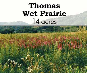

These 13.7 acres preserve wet prairie, sedge meadow, little pools, clumps of willow and a single large bur oak. Biologists have recorded over 200 plant species and scores of insect and spider species. When’s the last time you saw a crayfish tunnel in a prairie? Thomas Wet Prairie is full of them. It also home to a fuzzy-shelled old snapping turtle. Each summer, dozens of sedge wrens and a few snipe nest there. Bald eagles often visit the bur oak.
Thomas Wet Prairie is located in Grant County on County Trunk Highway G, approximately 7.5 miles south of the village of Muscoda and 8 miles north of the intersection with US Highway 18. 16403 County Road G, Muscoda 53573.

For decades, the Thomas family left their cattle in the wet prairie. Far from the barn, and too squishy for easy walking, cattle didn’t graze the land very hard. The Thomas family includes nature lovers. They never installed drain tile or broadcast sprayed the pasture with herbicide the way some farmers might. Their gentle approach to farming sustained the native community.
In the late 1980s, the Prairie Enthusiasts purchased 13.7 acres from the Thomas family with targeted funds from a major donor. Before then, volunteers had explored, documented and managed prairie remnants, but hadn’t acquired any land for permanent protection. At Thomas Wet Prairie, The Prairie Enthusiasts became a landowner for the first time.
Although Thomas Wet Prairie never had the dense brush that threaten many prairies, reed canary grass and hybrid cattails crowd out native species in parts of the preserve. To reduce their abundance, volunteers use a combination of frequent fire and selective herbicide treatment. When burning, volunteers leave half of the land unburned as a refuge for fire-sensitive species. Volunteers spread seeds of native species into the areas where they are removing pest species.

This site is 190 acres of native prairie and agricultural land. Once common in southern Wisconsin, prairies are very rare today. The 95,000-acre Military Ridge Prairie Heritage Area in Dane and Iowa counties contains one of the highest concentrations of native grasslands in the Midwest. It provides important habitat for plants and animals like meadowlarks and other grassland birds, which have disappeared in more developed parts of the region. The federally-endangered prairie bush clover occurs on The Nature Conservancy’s (TNC) land to the south. Because there is similar habitat on The Prairie Enthusiasts’ land, the population of this rare plant is expected to expand as restoration progresses. The adjacent land owned by TNC also has a population of the State Endangered regal fritillary butterfly, we expect it to move on to this portion of land as well, especially as restoration proceeds.

The primary goal is to restore the Thomas land back to its original open prairie, which is important for declining grassland birds and other wildlife. This will be a volunteer effort for the most part, and we welcome new volunteers. In the future, we hope to work with the community and our partners to form a “Friends of the Thomas Stone Barn” group to contribute the knowledge and expertise with historic buildings that we lack, and help make the barn a place where people can gather and experience our prairie and agricultural heritage.