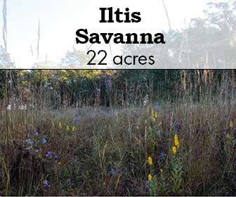
Iltis Savanna

Iltis Savanna

Photo credit: Jerry Newman

Iltis Savanna

Iltis Savanna is a 21.5 acre complex of woods, savanna and dry prairie that is adjacent to Muralt Bluff in the southeast quarter of Section 25 of Mt. Pleasant Township in Green County, Wisconsin.  It was purchased by The Prairie Enthusiasts in December, 1999, and it is named for Dr. Hugh H. Iltis, eminent Professor of Botany at the University of Wisconsin – Madison and Director of the UW Herbarium from 1955 to 1993.

This is a challenging hike as it’s long and steep; there are no trails.

SITE STEWARDS

PRAIRIE BLUFF CHAPTER

EMAIL

ACCESS & DIRECTIONS

Public access to Iltis Savanna is from the parking lot of Muralt Bluff, next to W2635 County F, between Monticello and Albany.  Take the hiking path up the steep bluff to the top of the hill, and then walk east toward the oak trees.

Google Map

Description & Significance

Iltis Savanna was the most degraded of our sites upon acquisition, and it remains the most challenging. An aerial photo from 1939 shows a mostly open landscape, with so few open-grown oaks that they can be counted.  Our fire regime has promoted the emergence of young oaks, to ensure that this savanna will endure into the 21st century. After significant efforts by members of the Prairie Bluff Chapter, native species are returning.

Notable Plants On This Site:

  • Various specis of Rubus
  • joe-pye weed (Eutrochium maculatum)
  • hyssop
  • shooting star
  • bush clover
  • various asters & goldenrod
  • showy orchid (Galearis spectabilis)
  • Indian pipe (Monotropa uniflora)
  • little bluestem (Schizachyrium scoparium)
  • prairie dropseed (Sporobolus heterolepis)
  • lead plant (Amorpha canescens)
  • Hill’s thistle (Cirsium pumilum var. hillii)
  • wood betony (Pedicularis canadensis)
  • bird’s foot violet (Viola pedata)
  • prairie violet (Viola pedatifida)
  • Ohio spiderwort (Tradescantia ohiensis)
  • violet wood sorrel (Oxalis violacea)

Usage Policies

Allowed:

  • Outdoor Recreation
  • Hunting (for all species, no permit or reservation required)

    Management

    South of these oaks is a 4-acre former agricultural crop field that included a large sumac clone and a honey locust grove when we re-started active management in 2009.  We used timed — twice in late summer — mowing to reduce the sumac to manageable numbers, which we then eliminated one-by-one.  We hired a contractor in 2016 to uproot the locusts, which we piled and burned.  See our Facebook page for a video, “One more acre for prairie.”  We began planting this field to prairie in 2014 with seeds we collected at our other sites, with three subsequent plantings.  Site preparation has been difficult due to deep-rooted brome grass and a seed bank of red clover.

    As you walk east along the north edge of this field, the unmanaged woodlot to your left in an example of what happens when grazing animals are removed from a farmstead that has a few oak trees.  Walnuts, hickories, cherries, cedars and basswoods eventually grow up, and the understory is filled in with raspberries, blackberries, dogwood, sumac, prickly ash and honeysuckle … lots of honeysuckle.

    The core of Iltis Savanna is a mature bur, white and red oak savanna that occupies a north-south ridge with a thin limestone cap over sandstone.  The oak structure remains, but 100 years of grazing by cows, pigs and horses eliminated almost all the floral element underneath.  Some sedges and spring ephemerals like trout lily were all that remained under the oaks.  Garlic mustard was a problem that we’ve controlled with prescribed fire.  We thinned out the northern portion with a basswood harvest.  Various species of Rubus quickly filled these open spaces, while hog peanut moved in to cover the south end with a blanket of vines.  But slowly, in the past decade, we’ve seen the natives begin to reclaim the savanna: joe pye weed, hyssop, shooting stars, bush clover, asters and goldenrods.  Showy orchids and Indian pipe can be seen most years.

    A keen eye will make out a former farm dump on the side of the bluff, halfway down the hill.  For ten years the chapter worked to clean out the trash: recycling fence wire and hauling off parts of cars, trucks, farm equipment, household appliances, toys, cans, bottles and broken glass.  Finally, in 2012, we hired a contractor to bury what was left of the dump.  There was not enough topsoil to cover it all, so a few truckloads of fill were brought in.  We began to plant dry prairie species — little bluestem, dropseed and lead plant — into the thin soil.  Hill’s thistle and wood betony are now common in this planting.  But the fill contained reed canary grass and the sweet clovers, which were problematic in the lower portion.

    Below the dump planting is a steep west-facing bluff.  Restoration started at the top, clearing cedars and brush and seeding in native grasses and forbs.  Between this bluff and the savanna is a strip of dry prairie dominated by little bluestem, with both bird’s foot and prairie violet, spiderwort, violet wood sorrel, asters, goldenrods and blazing stars.

    Butenhoff Prairie

    Butenhoff Prairie

    Butenhoff Prairie

    Butenhoff Prairie is a 19.5-acre broad-back hill in rural Green County. The Green County Conservation League purchased the hill from Harrison and Marion Butenhoff in 1988, and TPE bought the property in 2005. The remnant prairie sod still contains the original vegetation that greeted the first settlers in Green County in the late 1820s. 

    Two state listed plants are present.  Hill’s thistle (Cirsium hillii) and prairie Indian plantain (Arnoglossum plantagineum) are both listed as Threatened in Wisconsin by the Department of Natural Resources.  A third plant, prairie turnip (Psoralea esculenta) is shown on old plant lists but has not been seen recently.

    This property is considered hard to hike as it’s a long walk in; there are no trails at the site.  

    The photo at the above was taken May 15, 1988 at the dedication of Butenhoff Prairie.  From left: Kim Christen, president of the Green County Conservation League, John Ochsner and Dr. Hugh Iltis

    SITE STEWARDS

    TOM MITCHELL

    608-325-6228

    EMAIL

    ACCESS & DIRECTIONS

    Located roughly 1/3 mile north of the intersection CTY FF and Ladwig Road, located in the southeast quarter of Section 5 of Sylvester Township (T2N, R8E) in Green County. There is no easy access to this site, no fire number, no marked entrance lane or parking lot. Instead we have a 20-foot wide driveway easement north from County FF, between Dutch Hollow and Ladwig Roads that follows fence lines approximately two-thirds of a mile to the base of the broad hill. It is not recommended that visitors attempt to take passenger cars off-road to the site. When we have work days or field trips we meet along County FF and take 4-wheel drive trucks, which can navigate the hills, wet spots and steep climb up onto the limestone ridge.

    Google Map

    Description & Significance

    Photo credit: Jerry Newman

    The property is dry to mesic prairie, dominated by the short grasses  – little bluestem (Schizachyrium scoparium), side oats gramma (Bouteloua curtipendula) and prairie dropseed (Sporobolus heterolepis), with some big bluestem (Andropogon gerardii) and Indian grass (Sorghastrum nutans). It is rich is forbs, especially, asters and goldenrods.  The property is an irregularly shaped polygon of eight sides with a narrow band of trees and brush around the north, west and south sides.

    Butenhoff Prairie is significant in that its thin, rocky soil has prevented most of it from being plowed, although it most likely has been grazed by horses, sheep and cattle.  Flint, chert and other small chunks of limestone and dolomite rocks are present near the surface of the bluff, forming a cap over sandstone slopes that in turn lie above level, fertile ground.  There is a barb-wire fence along the east border of the property, and the other three sides are a brushy woodlot, especially where it is steep on the west and south edges.

    Forty years ago when this land was first found to be remnant prairie, upland sandpipers were common nesting birds.  The state-listed regal fritillary (Speyeria idalios) was once seen. However, since that time much of the surrounding area has been converted to housing and agricultural, reducing available grasslands from several hundred acres to a mere 20 acres. Formerly open areas have grown up the trees and brush. Eastern meadowlarks, bobolinks, grasshopper sparrows, field sparrows and dickcissels are still found nesting here most summers.
     
    Butenhoff Prairie features several small plum groves, which we protect from fire, plus hawthorns and the native Iowa crab.

    Usage Policies

    Allowed:

    • Outdoor Recreation
    • Hunting (for all species, no permit or reservation required)

      Ownership History

      Photo credit: Jerry Newman

      The preserve was purchased in January, 1988, by the Green County Conservation League from Harrison and Marian Butenhoff.  It was subsequently sold in 2005 to The Prairie Enthusiasts. It is owned outright in fee simple by TPE, with a legal easement from County FF through two parcels of land.

      It was pure serendipity that this was ever preserved.  This land was owned by Harrison Butenhoff, a Monroe businessman who was a member of the Green County Conservation League.  In the 1970s he contacted the Green County conservation people with the idea of planting pine trees on his property.  The tree-planter was another member of the league, Gary Eldred, who was also a prairie enthusiast. Eldred informed Butenhoff that he owned an unusual piece of Green County – prairie – and this rare ground would be lost forever if it were planted to trees.  So, over the next several years, arrangements were made to sell the land in 1987 to the Green County Conservation League. Within a few years, the league realized that a better fit would be for ownership and management to be transferred to the newly organized Prairie Enthusiasts.

      The original protection of this property coincided with the publication of Rudy’s Hill – The High Point in the Valley and A View of Life Beyond the Horizon by Manuel Conrad Elmer, whose memoir of growing up in Dutch Hollow was written as he approached his 100th birthday in 1986. His stories of learning the birds and bees, flowers and trees from his Swiss-born grandfather while they tramped the land surrounding what we now call Butenhoff Prairie, lends charm and literary history to the property.
       
      “Boots got the idea that M.C. Elmer’s Rudy’s Hill included his hill prairie,” remembers Gary Eldred, “and I think that clinched the deal for him to sell the land to the league.  He wanted it preserved.”

      Management

      The first burn at this site was conducted in the spring of 1988 by the league, many of whom were also Prairie Enthusiasts – Eldred, John Ochsner and Gary Felder.  This burn was held at night and attracted large numbers of spectators, whose cars lined County FF to see the rare sight of a prairie afire at night.  On the day before the transfer of title was to be celebrated by TPE in 1993, the league inadvertently set fire to the prairie, so that on dedication day there were no flowers to be seen, only blackened soil. Dr. Hugh Iltis was The Guest Speaker that day in 1993, and the prairie enthusiasts had to travel to nearby Sulzer Prairie to see any spring flowers.

      Early efforts by both the league and The Prairie Enthusiasts to restore the prairie to its original condition did not include herbicide use on the cut stumps, so that all of the cherry, walnut, elm and honeysuckle quickly re-sprouted.  Management techniques had improved by 2009, and in recent years all the invasive trees and most of the brush have been removed – permanently this time.  Plants introduced by the league include compass plant, pale purple coneflower, wild quinine and rattlesnake master.

      Tom Mitchell, the site steward, has organized work parties since 2009.  Work parties are held periodically during three seasons; our access is generally impassable during winter due to snow, ice or muddy conditions.

      Seasonal work at Butenhoff Prairie emphasizes the control of weeds and brush during the spring and summer months.  Non-native plants of lesser concern are the sweet clovers, wild parsnip and wild carrot, which are managed by hand when present in small patches and mowed when found in larger patches.  Trees and brush have been removed from a former fence line on the northern boundary.

      The southeastern portion of Butenhoff Prairie has an infestation of the non-native leafy spurge (Euphorbia esula), a perennial that is native to Europe and Asia.  It is deep-rooted with milky sap in all parts of the plant.  In Wisconsin, it is a restricted plant –an invasive this is already established in the state and has the potential to cause significant environmental or economic harm. Leafy spurge is one of five “noxious” weeds in Wisconsin, and according to the Invasive Plants Association of Wisconsin (IPAW), it can quickly create monocultures, excluding native vegetation and reducing wildlife habitat value.  We have used bio-controls – flea beetles – to reduce the prevalence of leafy spurge.

      Briggs Wetland

      Briggs Wetland

      Photo credit: Jerry Newman

      Briggs Wetland

      Briggs is a 24-acre parcel of wet prairie and wetland (with artesian springs).  Briggs was purchased from the Reorganized Church of Later Day Saints in 1994 by the Natural Land Institute of Rockford, Illinois. The buy was assisted through cooperative fund raising by the Prairie Bluff Chapter and a big grant from the Wisconsin Department of Natural Resources.

      Briggs was transferred to TPE in 1996. We routinely burn Briggs Wetland, and skirmish the invasive aliens like buckthorn (Rhamnus cathartica) and Canada thistle (Circium arvense). We have about 4 acres of tilled field we are planting to prairie on the south side.

      This property is considered difficult to hike; there are no trails on the prairie. 

      SITE STEWARDS

      FRED FAESSLER

      608-214-3203

      ACCESS & DIRECTIONS

      Briggs Wetlands lies on the west side of Brostuen Road between Beloit-Newark Road and Cleophus Road northwest of Beloit in Rock County, Wisconsin. State highways 11 and 213 are the nearest main arteries for visitors. There is no parking lot, but you can park along the east side of Brostuen Road. Access is by foot-traffic only. There are two springs near the sign on the east edge of the property. A wet prairie contains many tussock sedges (Carex stricta) which make hiking difficult.

      Google Map

      Description & Significance

      The flora of Briggs Wetlands is highly diverse and includes typical wetland species.

      An artesian spring emanates from a shallow, sandy-bottomed pool near the east edge of Briggs Wetland, and the rapid-running brook that leaves the pool is about 24-inches wide and flows west toward Raccoon Creek.  This stream is very clear, and it never freezes, although nearest to the springs it is full of non-native watercress.

      Among the conservation biologists who have studied Briggs Wetlands (mostly during the 1990s) were Prairie Enthusiast Rob Baller, Michael Jones and Rachel Cough of Natural Land Institute, UW entomologist Andrew Williams, Wisconsin Herbarium curator Ted Cochrane, Trish Roberts of The Nature Conservancy, and Richard Newsome of Beloit College.

      Notable Plants

      • marsh marigold (Caltha palustris)
      • golden alexanders (Zizia aurea)
      • meadow rue
      • cotton grass
      • mountain mint (Pycnanthemum virginianum)
      • bluejoint grass (Calamagrostis canadensis)
      • Turk’s cap lily (Lilium michiganense)
      • prairie blazing star (Liatris pycnostachya)
      • Riddell’s goldenrod (Solidago riddellii)
      • turtle head (Chelone glabra)
      • bottle gentian (Gentiana andrewsii)
      • and at least 18 species of sedges.

      Species Suggestive of a Fen Community

      • Muhly grass (Muhlenbergia richardsonis)
      • edible valerian (Valeriana edulis)
      • star sedge (Carex echinata)
      • Kalm’s lobelia (Lobelia kalmii)

      Natural History

      Briggs Wetland is part of a larger tract of wet prairie, sedge meadow, fen and shrubland along the East Fork of Raccoon Creek that has been designated a Wisconsin State Natural Area to recognize the quality and rarity of this natural community.  Briggs Wetland contains a perennial bubbling artesian spring that flows over a sandy bottom a few hundred meters to the southwest, where this stream joins Raccoon Creek.  The east fork is one of the few trout streams in Rock County, hosting native brook trout subject to catch & release regulations.

      Waterfowl that nest in the Raccoon Creek corridor include Wood Ducks, Mallards and Blue-Winged Teal.  Other migratory birds found in the wetlands are Green-Winged Teal, Gadwall, Widgeon, Kingfisher, Kingbird, Sedge Wren, Swamp Sparrow, Willow Flycatcher, Northern Harrier, Common Yellowthroat, Virginia Rail, Sora Rail, Great Blue Heron and Sandhill Crane.

      Protected land nearby Briggs Wetland is 28 acres to the northwest owned by the Green Rock Audubon Society and 33 acres to the southwest owned by The Prairie Enthusiasts (Newark Road Prairie) that is a dedicated State Natural Area.

      Usage Policies

      Allowed:

      • Hiking
      • Hunting (all species; no permit or reservation required)
      • Birding

        Not Allowed:

        • ATVs, Snowmobiles, or other Motorized Vehicles
        • Camping
        • Horseback Riding
        • Picnics

        Ownership History

        According to a historical plaque on the east side of Brostuen Road, the site has special religious significance to the Church of Jesus Christ of Latter-Day Saints and is named in honor of Jason W. Briggs (1821-1899), an early follower of the religion that was founded in 1830 by Joseph Smith Jr. in New York.  After Smith’s death by a mob in 1844 in Illinois, the leadership was contested.

        “On November 18, 1851, while praying for guidance (on the prairie near this site) Briggs received a startling revelatory experience.  His record of that experience became the foundation of what soon came to be called the New Organization.  The Wisconsin branches at Newark, Beloit, Waukesha and Yellow Stone, together with others in Northern Illinois united to reorganize the church in 1852.  Briggs and other interim leaders held the scattered groups together through the rest of the 1850’s.  Several early conferences of the church were held on a campsite around a spring across the road from this site.”

        By the 1990s the church had re-purchased the Briggs farm on both sides of Brostuen Road.  In 1994 the church reduced the sales price of this wetland to a non-profit conservation group, the Natural Land Institute of Rockford, Illinois, with the stipulation that it be named Jason Briggs Wetland after the patriarch of that reorganized branch of the LDS church. In December of 1996 the Prairie Enthusiasts bought the property from NLI, with one-half of the appraised value paid from the Wisconsin Nelson-Knowles Stewardship Fund.

        Management Activities by the Prairie Enthusiasts

        Recent management activities by Fred Faessler and other volunteers have focused on removal of buckthorn and willows from the areas south and east of the wetlands, which are remarkably free of brush and weeds, and the creation of a permanent firebreak. Prescribed burns have been infrequent, with some portions burned in 1995, 1996, 2000, 2007, 2011, 2018 and 2024.

        Avon Ridge

        Avon Ridge

        Avon Ridge

        This site has a panoramic view over the valley of Sugar River into Illinois. Habitat includes riverine grasslands and floodplain forest known as Avon Bottoms. Compass plant (Silphium laciniatum), prairie sunflower (Helianthus pauciflorus), and Carolina rose (Roas carolina) are just some plants commonly found on this scenic spot.


        View of blazing stars and sunflowers at Avon Ridge. Photographer Unknown.

        Avon Ridge

        View of blazing stars and sunflowers at Avon Ridge. Photographer Unknown.

        This site has a panoramic view over the valley of Sugar River into Illinois. Habitat includes riverine grasslands and floodplain forest known as Avon Bottoms. Compass plant (Silphium laciniatum), prairie sunflower (Helianthus pauciflorus), and Carolina rose (Roas carolina) are just some plants commonly found on this scenic spot.

        Access & Directions

        Visitors should park in the small gravel parking lot off Beloit-Newark Road, a half-mile east of Nelson Road, in the Rock County town of Avon, which is west of Beloit and southeast of Brodhead.  Take Highway 81 out of Brodhead a few miles and turn south on Nelson Road, then east on Beloit-Newark.  The nearest fire number is 15347 W. Beloit-Newark Road for our neighbor to the west.  From the parking lot walk south along the fence line, up the hill and over the ridge to the south-facing one-acre prairie.   Foslin Bluff is the extension to the west. The original one-acre remnant is over the ridge. To the east is planted prairie, in a 10-year CRP federal contract we inherited from the previous owner. 

        This property can be difficult to walk as there are no trails and the parking lot is quite far from the prairie.

        Google Map

        Site Steward

        Connect with the site steward to see how you can care for this rare habitat at an upcoming work party.

        This site is stewarded by The Prairie Enthusiasts Prairie Bluff Chapter

        Site Steward: Nick Faessler:(608) 214-3852 or Email

        How to Enjoy This Site

        Allowed:

        • Hiking
        • Birding
        • Wildlife Photography
        • Hunting

            Not Allowed:

            • Use of Motorized Vehicles or Bikes
            • Camping
            • Picnics
            • Horseback Riding

            How to Enjoy This Site

            Allowed:

            • Hiking
            • Birding
            • Wildlife Photography
            • Hunting

                Not Allowed:

                • Use of Motorized Vehicles or Bikes
                • Camping
                • Picnics
                • Horseback Riding


                Pale purple coneflower at Avon Ridge. Photo by Jerry Newman.

                What Makes Avon Ridge Special

                This remnant habitat (never having been plowed or grazed) features a spectacular show of rare native plants. One of the most striking features is the abundance of pale purple coneflowers (Echinacea pallida), which is a protected plant at the northern edge of its range in North America. Botanical range maps show this coneflower primarily in Rock, Green, Dane and Grant Counties while extending south and west. Authors Cochrane and Iltis is their Atlas of Wisconsin Prairie & Savanna Flora describe these confeflowers as a “southern Midwest prairie and plains species, once common and now rather rare.” Artists, photographers and nature-enthusiasts will enjoy this iconic plant’s blooms during June and July.

                The area’s ridge is capped with limestone and underlain by sandstone that has eroded into sloping side hills. Limestone is a hard rock that resists erosion. Sandstone is a softer rock.


                Part of a Larger Landscape

                This property is part of the Avon Bottoms Wildlife Area, an area spanning 4,356 acres of lowland. The habitat consists of numerous sloughs and old ox-bows and lowland hardwood forest containing swamp white oaks, silver maples, black willow, shagbark hickory, hackberry, green ash, cottonwood, bitternut hickory, bur oaks, basswood and sycamore trees.


                There are two Wisconsin State Natural Areas embedded in Avon Bottoms: 40-acre Swenson Wet Prairie State Natural Area and 168-acre Avon Bottoms State Natural Area. Avon Bottoms has been declared a Wisconsin Important Bird Area for its breeding populations of the cerulean and yellow-throated warblers, Acadian flycatcher and yellow-crowned night-heron.

                Spring blooms at Avon Ridge. Photo by Jerry Newman.

                How was Avon Ridge Protected

                Prairie Bluff Chapter Member and Past President Rob Baller first visited this site in the 1980s with neighbor Brad Paulson. The Chapter was interested in purchasing the remnant prairie land since the Chapter’s beginnings around 1987. The property consisted of parcels with three different owners. At that time, the land was sold to an Illinois couple and enrolled it in CRP. Again in 2004, the Prairie Bluff Chapter attempted to raise money to buy some of the prairie, but the agreement fell apart. In 2014, Chapter members noticed the land was once again for sale, and in 2015, The Prairie Enthusiasts were able to successfully purchase the land. The sale consisted of an acre of the remnant prairie, a CRP buffer and a strip of land to provide access to the site. 

                The original purchase consisted of a 16.5-acre parcel. Five years later in 2020, The Prairie Enthusiasts were able to add another 5.9 acres with the purchase of Foslin Bluff,  creating a contiguous 22.4-acre site. Both the addition and the original parcel were purchased with funds from the Wisconsin Knowles-Nelson Stewardship Fund and support from members of The Prairie Enthusiasts. 

                Prairie Enthusiasts enjoying the blooms of Avon Ridge. Photo by Jerry Newman.

                How You Can Help Avon Ridge

                The Prairie Bluff Chapter is stewarding the site by removing a troublesome invasive plant, crown vetch, which is present in a small area of both the CRP and remnant prairie. However the entire property is remarkably free of weeds and brush. Periodic weed patrols are conducted in spring and summer, and seed collection is done in summer and fall. Prescribed burns are also conducted on the site to ensure the habitat maintains it’s health.

                Check out our Events Calendar to see upcoming work parties or contact the site steward to get involved.

                Previously, work crews from the Chapter removed most of the trees and brush from the western portion of the remnant prairie during the winter of 2015-16.  Sawyers took out cedars, mulberries, cherries, apples, sumac and buckthorn, and then hauled them to the burn pile with a skid steer.

                Volunteers also took out 531 feet of old fence line, woven wire and three tangled and buried strands of barbed wire on the site, which were sold to a recycler.

                Volunteers clearing brush at Avon Ridge. Photographer Unknown.